The elevations of this mountain range do not reach those of other sectors of the
Central System (especially the Sierra de Gredos), but they offer
aerial tours like there are few in the center of the peninsula.
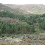
There where the leafy masses of oaks and chestnuts open up,
great panoramas appear before the eye: the Alagón valley to the south, the granitic masses that enter Portugal from the west and the
mountains of the Sierra de Gata receding to the east.
Except for brief sections that preserve vestiges of the old route, the
roads appear impeccable, lonely and hardly any traffic, of
medium size and with a hypnotic sinuosity in much of the
route.
Three ports mark the limit between the large pastures of
Extremadura and the lands of Salamanca. the old port (1108 m), the more
occidental, located right on the border with Portugal, Halfway
between Valverde del Fresno and Navasfrías, offers a huge stretch
suggestive.
The route to the port of Santa Clara (1040 m), that meanders from
Cilleros to Salamanca El Payo, is accurately advertised as
“scenic road”. The tour is lovely.
The third is the port of Perales (910 m), frequented the weekends
week by numerous motorists from Salamanca and Cáceres who come
attracted by its entertaining curves. Access to this pass from the north
by CL-526, which part of Ciudad Rodrigo, It is rectilinear and presents
some of the most attractive straights in all of Castilla y León.


